Highlands: Difference between revisions
From Halopedia, the Halo wiki
(Undo revision 902273 by Radical Edward2 (talk)) |
SPARTAN-347 (talk | contribs) (→Trivia) |
||
| Line 47: | Line 47: | ||
*The crashed Pelican's cockpit emits a [[Halo: Reach radio conversations|radio conversation]]. | *The crashed Pelican's cockpit emits a [[Halo: Reach radio conversations|radio conversation]]. | ||
*The Covenant Cruisers hovering in the sky are not static; they wobble from side to side slightly. | *The Covenant Cruisers hovering in the sky are not static; they wobble from side to side slightly. | ||
*This map features UNSC-constructed teleporters, confirming that humanity had at least limited access to this technology as of the Fall of Reach. | |||
==Gallery== | ==Gallery== | ||
Revision as of 18:04, April 16, 2011
Template:Ratings Template:Multiplayer Map Infobox
Highlands is one of three maps in the Defiant Map Pack designed for Halo: Reach.[1] The map is set in a UNSC SPARTAN-II training facility in the Military Wilderness Training Preserve within the Highland Mountains on Reach. Outside the playable space, Covenant battlecruisers can be seen glassing the surrounding environment.
Locations
The following are locations on the map that are so named on the player's heads-up display during gameplay:
- Operations
- Motor Pool
- Waterfall
- Communications
- Rock Arch
- Red Base
- Red Tower
- West Cave
- Underpass
- Pond
- Rappelling Towers
- Blue Base
- Blue Tower
- Big Horn River
- Radio Tower
- Crash Site
- East Cave
- Cliffs
- Out of bounds...
Trivia
- This is one of two maps to feature locations previously described in the novel Halo: The Fall of Reach, the other being Condemned.
- This level's design is similar to that of the Halo: Combat Evolved campaign level Halo.
- The crashed Pelican was carrying Spartan-IIs in the midst of the Fall of Reach.[2] They leapt out of the doomed Pelican, dropping into the Highland Mountains in the Viery Territory.
- The crashed Pelican's cockpit emits a radio conversation.
- The Covenant Cruisers hovering in the sky are not static; they wobble from side to side slightly.
- This map features UNSC-constructed teleporters, confirming that humanity had at least limited access to this technology as of the Fall of Reach.
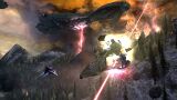
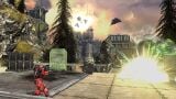
Gallery
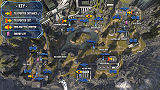
An overhead image of Highlands.
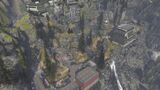
A general view of the map.

The east cave.

A battle on the map.
A Spartan Laser shot destroying a Falcon.
A Spartan destroying a Banshee.
- Defiant concept 4.jpg
Concept art of the map, showing a more lush art direction than in the final map.
- Defiant concept 3.jpg
A concept art piece depicting Covenant ships glassing the surrounding landscape.


Sources


