Halopedia:Projects/Mombasa Mapping: Difference between revisions
From Halopedia, the Halo wiki
CMDR RileySV (talk | contribs) No edit summary |
No edit summary |
||
| (13 intermediate revisions by 3 users not shown) | |||
| Line 1: | Line 1: | ||
{{Status|Halopedia}} | |||
The '''Mombasa Mapping Project''' aims to cross-reference both in-game and supplementary material to attempt to make sense of Mombasa's regional structure. | The '''Mombasa Mapping Project''' aims to cross-reference both in-game and supplementary material to attempt to make sense of Mombasa's regional structure. | ||
| Line 16: | Line 17: | ||
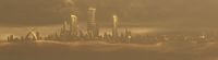
File:Mombasa View From Sky.jpg|The entirety of Mombasa island and some of the mainland as seen in ''Halo 3: ODST''. | File:Mombasa View From Sky.jpg|The entirety of Mombasa island and some of the mainland as seen in ''Halo 3: ODST''. | ||
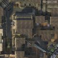
File:HA - Breakneck Overview.jpeg|Overhead of Breakneck from ''Halo: Reach''. | File:HA - Breakneck Overview.jpeg|Overhead of Breakneck from ''Halo: Reach''. | ||
File:H3ODST Uplift Nature Reserve Overhead.jpg|Overhead of [[Uplift Reserve]] from ''Halo 3: ODST''. | |||
File:H3ODST - Waterfront Highway Overhead.jpg|Overhead of [[Coastal Highway]] near Uplift Reserve from ''Halo 3: ODST''. | |||
File:H2 Turf Overhead.jpg|Overhead of Turf from ''Halo 2''. | |||
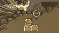
File:H2 - MombasaDev2.jpg|An overhead behind the scenes shots of the city as seen in cutscene and the ''Halo 2'' [[main menu]]. | |||
</gallery> | </gallery> | ||
When | With all the available information given, rough maps of the city can be constructed. | ||
<gallery> | |||
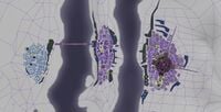
File:Mombasa Area Map.png|When starting with for real world geography, and layering the fictional locations of the city on top, a rough map can be constructed. | |||
File:UR - Mombasa Maps and Levels Connected.png|When starting with the levels and maps and trying to connect each one relative to one another, a different map can be formed. | |||
</gallery> | |||
==Resources== | ==Resources== | ||
| Line 33: | Line 41: | ||
*[[Sadie's Story]] - A complimentary story to main narrative of ''Halo 3: ODST''. Provides some new information. | *[[Sadie's Story]] - A complimentary story to main narrative of ''Halo 3: ODST''. Provides some new information. | ||
*[[Breakneck]] - A map set in Mombasa in ''[[Halo: Reach]]''. | *[[Breakneck]] - A map set in Mombasa in ''[[Halo: Reach]]''. | ||
*[[Bazaar]] and [[Streets]] - Two maps set in Mombasa in ''[[Halo Infinite]]''. These maps explicitly take place in a post-[[Project Rebirth]] Mombasa, and it is not fully known how faithful the rebuilt city is to its original form. | |||
==Confirmed information== | ==Confirmed information== | ||
*''Palace Hotel'' confirms that the | *''Palace Hotel'' confirms that (at least the tunnel Master Chief enters) at the end island end of the long suspension bridge is the Mtangwe Underpass. | ||
*Halo Waypoint confirms that Headlong/[[Section 14]] is on the mainland and a monitoring outpost | **It also confirms that [[Moi Avenue]] had a junction with this tunnel | ||
**Based on descriptions and the sequence of events, the domed park is [[Kilindini Park Cultural Center]]. | |||
*Halo Waypoint confirms that Headlong/[[Section 14]] is on the mainland and a monitoring outpost for [[Nyali]], Tudor and New Mombasa island.<ref name="mombasa waypoint">[https://www.halowaypoint.com/en-us/universe/locations/new-mombasa ''Halo Waypoint'': New Mombasa]</ref> | |||
**Halo Waypoint also confirms that the Prophet of Regret's ship entered slipspace north-east of the city.<ref name="mombasa waypoint"/> | |||
*''ODST'' confirms that [[Uplift Reserve]] is the landing site of ''Solemn Penance''. | |||
*''Sadie's Story'' confirms there is a bridge on the other side of the island connecting [[Tononoka]] with [[Obote]] (the mainland). | |||
**''Sadie's Story'' also repeatedly refers to locations visited across ODST's gameplay as part of the City center, meaning that the locations seen in the various levels including Mombasa Streets are part of the City center. | |||
==Discrepancies== | |||
*'''Mombasa''' - The entire city has been quite radically redesigned several times with the island portion of the city being seen in different configurations and designs. See the above collection of overheads and maps to see these drastic design differences | |||
*'''New Mombasa 105 E Bridge''' - The large cable-stayed bridge seen in ''Halo 2''/''Halo 2: Anniversary'' is slightly different in design from the one seen in ''Spartan Strike''. Notable issues include width and and differences in median (the one in ''Halo 2''/''Halo 2: Anniversary'' features a metal median while the one in ''Spartan Strike'' is glass). | |||
*'''Mombasa Tether''' - Mombasa Tether has been shown to be on it's own island, shown to be a part of either the mainland, or part of Mombasa island itself. The tether itself has varied quite a bit. | |||
*'''Section 21''' - Many details of Section 21 are quite inconsistent with other incarnations of the city. For one, what is supposed to be Uplift Reserve is incredibly close. The skyline's orientation also doesn't quite make sense relative to the compass. | |||
*'''Makupa-Hope''' - In ''Sadie's Story'', from [[Kikowani Station]], Sadie boards a train that stops at [[Makupa]], [[Nairobi Road]] and [[Hope Station]] before terminating at the suburb of [[Magongo]]. In ''Halo Infinite'', the map [[Streets]] portrays Makupa Station and Hope Station as mutual interchanges, with both stations being accessible from the same entrance. There are several possibilities as to why the line would seemingly loop around on itself before leaving Mombasa: Since Streets takes place post-war, it could represent a completely new transit system with a new layout that isn't relevant to Sadie's experience. An alternate explanation is that Sadie boarded a train on a commuter rail network distinct from the [[New Mombasa MagLev train network]]. Evidence for this includes the fact that her train is dispatched by a conductor (unusual for an urban rapid transit system), and the fact that her train terminates in a distant suburb with very few stops in-between. In this hypothesis, the Makupa and Hope Stations that Sadie would pass through are distinct from the Makupa and Hope stations on the Mombasa [=MagLev=]. | |||
==Locational hierarchy== | |||
*Mainland | |||
**[[West Market]] | |||
***[[Haller Street]] | |||
***[[The Corner]] | |||
**[[Kuku Street]] | |||
**[[The Roost Star]] | |||
**[[Kuku's Cafe]] | |||
**[[Grid Kilo 23]] | |||
**[[Mombasa Quays]] | |||
***[[Captain J. Bennier Mombasa Inlet]] | |||
****[[Mombasa Inlet Plant]] | |||
**[[Obote]] | |||
***[[Old Town Market]] | |||
**[[Makupa]] | |||
**[[Kwakiziwi]] | |||
**[[Koinage]] | |||
**[[Nyali]] | |||
***[[Nyali Station]] | |||
**[[Mtongwe Station]] | |||
**[[Hope Station]] | |||
**[[Makupa]] | |||
***[[Makupa Station]] | |||
**[[Sector 0-5]] | |||
***[[Liberty Street]] | |||
***[[Hotel Zanzibar]] | |||
***[[Voi Theater]] | |||
***[[Section 0-5 UEG Storage Facility]] | |||
**[[Section 14]] | |||
**[[Section 21]] | |||
***[[Unidentified hotel]] | |||
*[[New Mombasa Orbital Elevator|Orbital Elevator]] | |||
*Island | |||
**[[New Mombasa industrial zone|Industrial zone]] | |||
***[[New Mombasa Sector B|Sector B]] | |||
***[[Kilindini]] | |||
****[[Kilindini Station]] | |||
****[[Kilindini Park Cultural Center]] | |||
**[[New Mombasa City Center|City center]] | |||
***[[Tanaga]] | |||
****[[Vyrant Telecom tower (Mombasa)|Vyrant Telecom tower]] | |||
*****[[NMPD headquarters]] | |||
***[[Kizingo]] | |||
****[[New Mombasa Sector 0|Sector 0]] | |||
***[[New Mombasa Sector 1|Sector 1]] | |||
***[[New Mombasa Sector 2|Sector 2]] | |||
***[[New Mombasa Sector 3|Sector 3]] | |||
***[[New Mombasa Sector 4|Sector 4]] | |||
***[[Mbaraki]] | |||
****[[New Mombasa Sector 5|Sector 5]] | |||
*****[[Tayari Plaza (location)|Tayari Plaza]] | |||
***[[Lumumba]] | |||
****[[New Mombasa Sector 6|Sector 6]] | |||
****[[New Mombasa Sector 9|Sector 9]] | |||
***[[New Mombasa Sector 7|Sector 7]] | |||
***[[New Mombasa Sector 8|Sector 8]] | |||
***[[New Mombasa Sector 10|Sector 10]] | |||
****[[ONI Alpha Site (location)|ONI Alpha Site]] | |||
*****[[New Mombasa Data Center]] | |||
***[[Uplift Nature Reserve]] | |||
**[[Kilindini Harbor]] | |||
**[[Ivory Tower (location)|Ivory Tower]] | |||
**[[New Mombasa Sector A|Sector A]] | |||
**[[Tononoka]] | |||
**[[Kikowani]] | |||
**[[Beria Plaza]] | |||
**[[Palace Hotel (location)|Palace Hotel]] | |||
**[[New Mombasa Docks|Docks]] | |||
**[[Kikowani Station (location)|Kikowani Station]] | |||
**[[Liwitoni]] | |||
***[[Liwitoni Station]] | |||
**[[New Mombasa Waterfront Highway|Coastal Highway]] | |||
**[[New Mombasa 105 East]] | |||
**[[Kizingo Boulevard (location)|Kizingo Boulevard]] | |||
**[[New Mombasa 105 East#Bridge|Mombasa Suspension Bridge]] | |||
**[[Moi Avenue]] | |||
**[[Shimanzi Road]] | |||
**[[Manyimbo]] | |||
***[[Manyimbo Station]] | |||
*[[Nairobi Road]] | |||
==Theorycrafting== | ==Theorycrafting== | ||
| Line 45: | Line 148: | ||
File:H2ACampaign MetropolisBridge.png|The multi-towered building on the right. | File:H2ACampaign MetropolisBridge.png|The multi-towered building on the right. | ||
</gallery> | </gallery> | ||
*'''[[Section 21]]''' - Though there are some differences, when accounting for landmark placement and | *'''[[Section 21]]''' - Though there are some differences, when accounting for landmark placement and similar levels of building density, it does appear that Section 21 and the built up district with elephant horns might be the same. | ||
<gallery> | <gallery> | ||
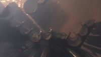
File:Old Mombasa.jpg|The elephant horns district from ODST. | File:Old Mombasa.jpg|The elephant horns district from ODST. | ||
File:HR Mombasa Skyline.png|View from Section 21 | |||
</gallery> | </gallery> | ||
| Line 59: | Line 163: | ||
===Characters=== | ===Characters=== | ||
Double check that locations and location based info is updated on various character related pages. | Double check that locations and location based info is updated on various character related pages. | ||
*{{AID|}} [[Superintendent]] | |||
*{{AID|}} [[Vergil]] | |||
*{{AID|}} [[Quick to Adjust]] | |||
*{{AID|}} [[Sadie Endesha]] | *{{AID|}} [[Sadie Endesha]] | ||
*{{AID|}} [[Daniel Endesha]] | *{{AID|}} [[Daniel Endesha]] | ||
*{{AID|}} [[Alpha-Nine]] | |||
**{{AID|}} [[Edward Buck]] | |||
**{{AID|}} [[Michael Crespo]] | |||
**{{AID|}} [[Jonathan Doherty]] | |||
**{{AID|}} [[Kojo Agu]] | |||
**{{AID|}} [[Taylor Miles]] | |||
**{{AID|}} [[Veronica Dare]] | |||
===Battles=== | ===Battles=== | ||
| Line 69: | Line 183: | ||
==See also== | ==See also== | ||
*[[Mombasa#Geography]] | *[[Mombasa#Geography]] | ||
*[[Halopedia:Projects/Reach Mapping|Reach Mapping Project]] | |||
==Sources== | ==Sources== | ||
{{Ref/Sources}} | {{Ref/Sources}} | ||
{{Halopedia IP}} | {{Halopedia IP}} | ||
Latest revision as of 10:46, June 3, 2022
The Mombasa Mapping Project aims to cross-reference both in-game and supplementary material to attempt to make sense of Mombasa's regional structure.
Goals[edit]
Current research[edit]
Because their have been many sources, both visually and written, describing and showing off the real world inspired Mombasa area, it is now possible to begin placing, collating and theorising about the landscape of Mombasa.
Official and IRL maps[edit]
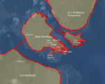
To begin, Mombasa is actually a real world city with a specific geography. As such, here is an IRL overview of the city. North is up in this image.

The Halo universe has revisited the city several times, in several styles with numerous locations. Here is a collection of various maps, and overhead images from around the city.
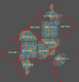
A collation of the various sector maps in Mombasa Streets.
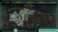
The overview of the area of the city seen in Operation A: Orphic Spear in Spartan Strike.
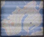
The Mombasa map seen in Terminal.

The entirety of Mombasa island and some of the mainland as seen in Halo 3: ODST.
Overhead of Breakneck from Halo: Reach.
Overhead of Uplift Reserve from Halo 3: ODST.
Overhead of Coastal Highway near Uplift Reserve from Halo 3: ODST.
Overhead of Turf from Halo 2.
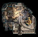
An overhead behind the scenes shots of the city as seen in cutscene and the Halo 2 main menu.


With all the available information given, rough maps of the city can be constructed.
When starting with for real world geography, and layering the fictional locations of the city on top, a rough map can be constructed.
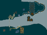
When starting with the levels and maps and trying to connect each one relative to one another, a different map can be formed.


Resources[edit]
Primary resources[edit]
- Halo 2 - Includes a swathe a lot of visual and narrative information on Mombasa.
- Halo 2: Anniversary - A modernization of some of these elements, providing even more details.
- Palace Hotel - A retelling of some Halo 2 events, providing even more details.
- Halo 3: ODST - Includes a vast amount of Mombasa related information, that comes in audio, visual, and narrative form.
- Halo: Spartan Strike - A new experience providing some new visual information.
Additional resources[edit]
- Second Sunrise Over New Mombasa - A comic story that provides some extra visual information.
- Sadie's Story - A complimentary story to main narrative of Halo 3: ODST. Provides some new information.
- Breakneck - A map set in Mombasa in Halo: Reach.
- Bazaar and Streets - Two maps set in Mombasa in Halo Infinite. These maps explicitly take place in a post-Project Rebirth Mombasa, and it is not fully known how faithful the rebuilt city is to its original form.
Confirmed information[edit]
- Palace Hotel confirms that (at least the tunnel Master Chief enters) at the end island end of the long suspension bridge is the Mtangwe Underpass.
- It also confirms that Moi Avenue had a junction with this tunnel
- Based on descriptions and the sequence of events, the domed park is Kilindini Park Cultural Center.
- Halo Waypoint confirms that Headlong/Section 14 is on the mainland and a monitoring outpost for Nyali, Tudor and New Mombasa island.[1]
- Halo Waypoint also confirms that the Prophet of Regret's ship entered slipspace north-east of the city.[1]
- ODST confirms that Uplift Reserve is the landing site of Solemn Penance.
- Sadie's Story confirms there is a bridge on the other side of the island connecting Tononoka with Obote (the mainland).
- Sadie's Story also repeatedly refers to locations visited across ODST's gameplay as part of the City center, meaning that the locations seen in the various levels including Mombasa Streets are part of the City center.
Discrepancies[edit]
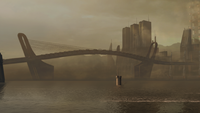
- Mombasa - The entire city has been quite radically redesigned several times with the island portion of the city being seen in different configurations and designs. See the above collection of overheads and maps to see these drastic design differences
- New Mombasa 105 E Bridge - The large cable-stayed bridge seen in Halo 2/Halo 2: Anniversary is slightly different in design from the one seen in Spartan Strike. Notable issues include width and and differences in median (the one in Halo 2/Halo 2: Anniversary features a metal median while the one in Spartan Strike is glass).
- Mombasa Tether - Mombasa Tether has been shown to be on it's own island, shown to be a part of either the mainland, or part of Mombasa island itself. The tether itself has varied quite a bit.
- Section 21 - Many details of Section 21 are quite inconsistent with other incarnations of the city. For one, what is supposed to be Uplift Reserve is incredibly close. The skyline's orientation also doesn't quite make sense relative to the compass.
- Makupa-Hope - In Sadie's Story, from Kikowani Station, Sadie boards a train that stops at Makupa, Nairobi Road and Hope Station before terminating at the suburb of Magongo. In Halo Infinite, the map Streets portrays Makupa Station and Hope Station as mutual interchanges, with both stations being accessible from the same entrance. There are several possibilities as to why the line would seemingly loop around on itself before leaving Mombasa: Since Streets takes place post-war, it could represent a completely new transit system with a new layout that isn't relevant to Sadie's experience. An alternate explanation is that Sadie boarded a train on a commuter rail network distinct from the New Mombasa MagLev train network. Evidence for this includes the fact that her train is dispatched by a conductor (unusual for an urban rapid transit system), and the fact that her train terminates in a distant suburb with very few stops in-between. In this hypothesis, the Makupa and Hope Stations that Sadie would pass through are distinct from the Makupa and Hope stations on the Mombasa [=MagLev=].
Locational hierarchy[edit]
- Mainland
- Orbital Elevator
- Island
- Nairobi Road
Theorycrafting[edit]
Hypothetical location placements[edit]
- Spartan Strike "On Top of the World" building - Although there are significant design and placement differences, there are number of similarities with this multi-towered building in Halo 2 and Halo 2: Anniversary and the one used as the backdrop for the Spartan Strike level "On Top of the World".
The multi-towered building can be seen on the left.
The multi-towered building on the right.


- Section 21 - Though there are some differences, when accounting for landmark placement and similar levels of building density, it does appear that Section 21 and the built up district with elephant horns might be the same.
The elephant horns district from ODST.
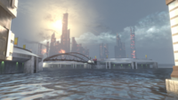
View from Section 21


Cleanup[edit]
Locations[edit]
Checked boxes indicate articles that have been updated with new info and images.
Characters[edit]
Double check that locations and location based info is updated on various character related pages.
Battles[edit]
See also[edit]
Sources[edit]
| |||||||||||