|
|
| (81 intermediate revisions by 43 users not shown) |
| Line 1: |
Line 1: |
| {{era|H2|H3}} | | {{Status|Canon}} |
| [[Image:Flag of the United Republic of Tanzania.png|200px|thumb|right]]
| | {{Wikipedia}} |
| The '''United Republic of Tanzania''' is a country in [[Africa|East Africa]]. It is bordered by Kenya and Uganda on the north, Rwanda, Burundi and the Democratic Republic of the Congo on the west, and Zambia, Malawi and Mozambique on the south. To the east it borders the Indian Ocean.
| | {{Affiliation infobox |
| | | |name=United Republic of Tanzania |
| [[Image:Location of Tanzania on Earth.png|200px|thumb|right]] | | |image=[[File:H3 Mount Kilimanjaro.jpg|300px]] |
| | | |type=Republic |
| The country is named after Tanganyika, its mainland part, and the Zanzibar islands off its east coast. Tanganyika united with Zanzibar in 1964, forming the "United Republic of Tanganyika and Zanzibar", which later the same year was renamed the "United Republic of Tanzania". In 1996, government offices were transferred from Dar es Salaam to Dodoma, making Dodoma the country's political capital. Dar es Salaam remains as the principal commercial city.
| | |founder= |
| | |documents= |
| | |head= |
| | |executive= |
| | |legislative= |
| | |judicial= |
| | |branch= |
| | |main= |
| | |anthem= |
| | |language=*[[Swahili]] |
| | *[[English]] |
| | |script= |
| | |religion= |
| | |techlevel= |
| | |notable-title= |
| | |notable= |
| | |formed= |
| | |affiliation=[[East African Protectorate]], [[UNSC]], [[Unified Earth Government]] |
| | }} |
| | '''Tanzania''', officially the '''United Republic of Tanzania''', is an [[Africa|East African]] coastal [[national government|nation]] on [[Earth]].<ref name="ENC">''[[Halo Encyclopedia (2009 edition)]]'', p. 296 (2011 edition)</ref> It is part of the [[Unified Earth Government]]'s [[East African Protectorate]].<ref name="zanzibar">''[[Halo 2]]'', multiplayer map ''[[Zanzibar]]'' (map description)</ref> |
|
| |
|
| ==History== | | ==History== |
| ===Prehistory===
| | [[File:LibrarianEarthCEA.jpg|200px|left|thumb|The Librarian in what would become Tanzania, prior to the [[Great Purification]].<ref>''[[Halo: Combat Evolved Anniversary]]'', [[Terminal (Halo: Combat Evolved Anniversary)]]</ref>]] |
| Tanzania is home to some of the oldest human settlements unearthed by archaeologists, including fossils of early humans found in and around Olduvai Gorge in northern Tanzania, an area often referred to as "The Cradle of Mankind". These fossils include Paranthropus bones thought to be over 2 million years old, and the oldest known footprints of the immediate ancestors of humans, the Laetoli footprints, estimated to be about 3.6 million years old.
| |
| | |
| ===Early history=== | | ===Early history=== |
| | {{Quote|You should see the mountain that watches over it. A beautiful thing - a snowcapped sentinel. That's where I will spend what time is left to me.|The Librarian to the [[IsoDidact]] near the end of the Forerunner-Flood war.{{Ref/Reuse|h3terminal}}}} |
| | In the waning days of the [[Forerunner-Flood war]], the [[Librarian]] oversaw the construction of the [[Portal at Voi]] and spent her last moments at Mount Kilimanjaro.<ref name="h3terminal">''Halo 3'', [[Terminal (Halo 3)|Terminal 6]]</ref> |
|
| |
|
| Reaching back about 10,000 years, Tanzania is believed to have been populated by hunter-gatherer communities, probably Khoisan speaking people. Between three and five thousand years ago, they were joined by Cushitic-speaking people who came from the north – into which the Khoisan peoples were slowly absorbed. Cushitic peoples introduced basic techniques of agriculture, food production, and later, cattle farming.
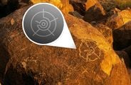
| | In [[2007]], the [[Society of the Ancients]] identified a [[Tanzanian petroglyph|petroglyph]] of the [[Forerunner]] Chrysopteron etched into a Tanzanian mountainside.<ref>[http://206.16.223.63/evidence.html Society of the Ancients evidence page]: ''This was just sent to me from a SOTA member traveling through Tanzania. The rock painting (as of yet undated) was pointed out last month by a local safari guide.''</ref> |
|
| |
|
| About 2000 years ago, Bantu Speaking people began to arrive from western Africa in a series of migrations. These groups brought and developed ironworking skills and new ideas of social and political organization. They absorbed many of the Cushitic peoples who had preceded them, as well as most of the remaining Khoisan-speaking inhabitants. Later, Nilotic pastoralists arrived, and continued to immigrate into the area through to the 18th century.
| | ===East African Protectorate=== |
| | By at least the 25th Century, Tanzania had become part of the [[East African Protectorate]]. Late in the 2400s, the EAP unsuccessfully attempted to re-nationalize a number of privatized industries that had previously been under state control.{{Ref/Reuse|zanzibar}} The [[United Nations Space Command]] established many bases in Tanzania throughout its history, especially capitalizing on the defensive capabilities of Mount Kilimanjaro, which had multiple bases built into its slopes.<ref name="ENC297">''[[Halo Encyclopedia (2009 edition)]]'', p. 297 (2011 edition)</ref> |
|
| |
|
| ===Indian Ocean trade===
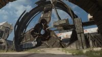
| | [[File:Sierra117grunts.png|thumb|200px|left|Spartan-117 engages [[Unggoy]] during the [[Battle for Earth]] in a Tanzanian jungle.]] |
|
| |
|
| Beginning in the early first Millennium CE, regular trade with Arabia and Persia made the East African coast economically strong. Later, Islam was introduced. Because of the Arabcentric doctrine of Islam, some Arabic influences entered the language -- resulting in the emergence of the Swahili language, a member of the Bantu family of languages, with Arabic influences. All along the coast, as well as on the islands of the Zanzibar archipelago and Kilwa, many trading cities thrived. Between the 13th and 15th centuries, in a period known as the Shirazi Era, these cities flourished, with trade in ivory, gold and other goods extending as far away as India and China.[6]. The Swahili influence was felt east to the islands of Comoros and Madagascar, as well as west into central Africa, the great lakes kingdoms, and Zimbabwe.
| | ===Covenant invasion=== |
| | {{Main|Recovery of John-117}} |
| | {{Quote|Chief, Pelicans are at the river. We've got company, so hustle up!|Avery Johnson.}} |
| | On November 17, [[2552]], late into the [[Battle for Earth]], the [[Prophet of Truth]] arrived aboard the [[Forerunner Dreadnought]]. The [[Spartan-II]] [[John-117]], after failing to kill the [[hierarch]], bailed from the ship as it entered the Earth's atmosphere, and landed in a jungle south of Mount Kilimanjaro. He was recovered hours later by a contingent of [[UNSC Marine Corps|marines]] and [[Thel 'Vadam]].<ref>''Halo 3'', campaign level, [[Arrival]]</ref> Before long, the group, aided by a few [[D77H-TCI Pelican]]s, engaged [[Covenant]] forces which been deployed to the jungle. [[Sergeant Major]] [[Avery Johnson]] and survivors of the [[Second Squad]] were captured and taken to the Covenant-occupied [[A2 Hydroelectric Facility]].{{Ref/Reuse|s117}} John-117 and The Arbiter made their way to the dam and worked to rescue the captives. After this, two {{Pattern|Ru'swum|Phantom}}s appeared and dropped off reinforcements. The UNSC forces held off the attack until the pelican [[Kilo 023]] arrived, destroying the Phantoms and extracting the humans and lone [[Sangheili]] to [[Crow's Nest (location)|Crow's Nest]] in [[Kenya]].<ref name="s117">''Halo 3'', campaign level, [[Sierra 117]]</ref> During the fight against the Covenant, the city of Arusha became a hotbed of Covenant activity.<ref name="Tsavo">''Halo 3'', campaign level, [[Tsavo Highway]]</ref> |
|
| |
|
| In the early 1300s Ibn Battuta, an international Berber traveler from North Africa, visited Kilwa and proclaimed it one of the best cities in the world. In 1498 Vasco da Gama became the first European to reach the East African coast, and by 1525 the Portuguese had subdued the entire coast. Portuguese control lasted until the early 18th century, when Arabs from Oman established a foothold in the region. During this time, Zanzibar became the center for the Arab slave trade. Due to the Arab and Persian domination at this later time, many Europeans misconstrued the nature of Swahili civilization as a product of Arab colonization. However, this misunderstanding has begun to dissipate over the past 40 years as Swahili civilization is becoming recognized as principally African in origin.
| | Following the end of the war, the member states of the EAP, including Tanzania, donated [[gold]] ore for a statue of [[John-117]] to be placed in the [[United Nations Space Command Memorial Park]] as part of [[Project Rebirth]], a plan for the rebuilding and revitalization of [[New Mombasa]].<ref>''[[McFarlane Toys/Halo Point Prizes]]'', Campaign Master Chief</ref> |
|
| |
|
| ===European colonialism=== | | ==Geography== |
| | Tanzania borders [[Kenya]].{{Ref/Reuse|ENC}} [[Tsavo highway (location)|Tsavo Highway]] connects [[Arusha]] in Tanzania and [[Voi]] in Kenya.{{Ref/Reuse|ENC}} In terms of landmarks, there is [[Mount Kilimanjaro]]. Where Kilimanjaro lies, is mountainous and home to dense jungles.{{Ref/Reuse|s117}} |
|
| |
|
| A German colony from the 1880s until 1919, the area subsequently became a British Mandate from 1919 to 1961. It served as a military outpost during WWII and provided financial help as well as munitions. Julius Nyerere became Minister of British-administered Tanganyika in 1960 and continued as Prime Minister when Tanganyikia became independent in 1961. Tanganyika and neighbouring Zanzibar, which had become independent in 1963, merged to form the nation of Tanzania on April 26, 1964. Nyerere introduced African socialism, or Ujamaa, which emphasized justice and equality.
| | ===Locations=== |
| | *[[Mount Kilimanjaro]] |
| | **[[Mount Kilimanjaro Water Plant]] |
| | *[[Arusha]] |
| | *[[Zanzibar Island]] |
| | **[[Zanzibar Municipal Turbine 7]] |
|
| |
|
| ====Tanganyika (1815–1886)==== | | ==Government== |
| | [[File:A2Dam 2.jpg|thumb|200px|The A2 Hydroelectric Plant during the Battle for Earth.]] |
| | Tanzania was controlled by the [[UNSC]].{{Ref/Reuse|ENC}} |
| | ===Power and water=== |
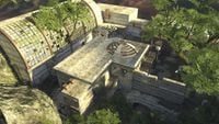
| | Snowmelt from Mount Kilimanjaro was once collected and used to distribute water across the entire African continent by the [[Global Water Campaign]] via [[GWC Trans-African Pipelines|GWC trans-African pipelines]].<ref>[http://halo.bungie.net/News/content.aspx?type=topnews&cid=13287 ''Bungie.net'': Ghost Town Revealed]</ref> The GWC's [[Mount Kilimanjaro Water Plant|main water treatment plant]] had fallen into disrepair by the 26th Century, but the government initiative continued to function at other locations, such as the [[A2 Hydroelectric Facility]], which uses a flowing river to generate electricity. The aforementioned decommissioned plant was acquired by the UNSC in the early 26th Century and was used to conduct classified military training exercises for ingress/egress operations and as a template for War Game simulations, specifically WAR GAMES MAP_SET/: 673-15.<ref name="universe">[https://www.halowaypoint.com/en-us/universe/locations/earth ''Halo Waypoint'': Earth]</ref> The Zanzibar Archipelago is home to [[Wind Power Station 7]].{{Ref/Reuse|zanzibar}} |
|
| |
|
| Tanganyika as a geographical and political entity did not take shape before the period of High Imperialism; its name only came into use after German East Africa was transferred to the United Kingdom as a mandate by the League of Nations in 1920. What is referred to here, therefore is the history of the region that was to become Tanganyika.
| | ==Trivia== |
| | *Wind Power Station 7 is the setting for the War Games Map_Set/: 680-4, a simulated environment used in the UNSC's [[War Games]].{{Ref/Note|Id=Spartans|The map description for ''Halo 3'''s [[Last Resort]] says that Wind Power Station 7 was requisitioned for use as part of Spartan training exercises. It is unknown whether this refers to the War Games or if Spartans trained at the actual location.}} |
|
| |
|
| The port of Zanzibar was visited by Dutch, English and French ships. The British East India Company had a representative on Zanzibar, who acted as an advisor to the sultan. In 1873 a British fleet forced Sultan Barghash to declare the end of the slave trade. Although reduced, an illegal slave trade continued. | | ==Gallery== |
| | <gallery> |
| | File:Arrivaldepart.jpg|Kilimanjaro at night. The Forerunner Dreadnought is visible in the sky. |
| | File:H3_GhostTownOverhead.jpg|The abandoned water purification plant near Mount Kilimanjaro. |
| | File:H2A - Stonetown.jpg|Wind Power Station 7. |
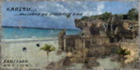
| | File:Halo2-Zanzibar-Advert.png|An advertisement for the Karisu Holiday Resort. |
| | File:SOTA symbol.jpg|A Forerunner glyph found in Tanzania. |
| | </gallery> |
|
| |
|
| In 1848 the German missionary Johannes Rebmann became the first European to see Mount Kilimanjaro, and in 1858 Richard Burton and John Speke mapped Lake Tanganyika.
| | ==List of appearances== |
| | *''[[Halo 2]]'' {{1st}} |
| | *''[[Iris]]'' |
| | *''[[Halo 3]]'' |
| | *''[[Halo 2: Anniversary]]'' |
| | *''[[Halo Mythos]]'' {{Mo}} |
| | *''[[Halo: Renegades]]'' |
|
| |
|
| In 1877 the first of a series of Belgian expeditions arrived on Zanzibar. In the course of these expeditions, in 1879 a station was founded in Kigoma on the eastern bank of Lake Tanganyika, soon to be followed by the station of Mpala on the opposite western bank. Both stations were founded in the name of the Comite D'Etudes Du Haut Congo, a predecessor organization of the Congo Free State. The fact that this station had been established and supplied from Zanzibar and Bagamoyo led to the inclusion of East Africa into the territory of the Conventional Basin of the Congo at the Berlin Conference of 1885.
| | ==Notes== |
| | | {{Ref/Notes}} |
| At the table in Berlin, contrary to widespread perception, Africa was not partitioned; rather, rules were established among the colonial powers and prospective colonial powers as how to proceed in the establishment of colonies and protectorates. While the Belgian interest soon concentrated on the Congo River, the British and Germans focused on Eastern Africa and in 1886 partitioned continental East Africa between themselves; the Sultanate of Zanzibar, now reduced to the islands of Zanzibar and Pemba, remained independent, for the moment.
| |
| | |
| The Congo Free State was eventually to give up its claim on Kigoma (its oldest station in Central Africa) and on any territory to the east of Lake Tanganyika, to Germany.
| |
| | |
| ====The Maji Maji War====
| |
| | |
| All resistance to the Germans in the interior ceased and they could now set out to organize German East Africa. They continued to brutally exercise their authority with disregard and contempt for existing local structures and traditions. This led to the re-emergence of widespread discontent, and in 1902 a movement against forced labour for a cotton scheme rejected by the local population started along the Rufiji River.
| |
| | |
| The tension reached a breaking point in July 1905 when the Matumbi of Nandete led by Kinjikitile Ngwale revolted against the local administrators (akida) and suddenly the revolt grew wider from Dar es Salaam to the Uluguru Mountains, the Kilombero Valley, the Mahenge and Makonde Plateaux, the Ruvuma in the southernmost part and Kilwa, Songea, Masasi, and from Kilosa to Iringa down to the eastern shores of Lake Nyasa.
| |
| | |
| Known as the Maji Maji war with the main brunt borne by the Ngoni people, this was a merciless rebellion and by far the bloodiest in Tanganyika.
| |
| | |
| Germans had occupied the area since 1897 and totally altered many aspects of everyday life. They were actively supported by the missionaries who tried to destroy all signs of indigenous beliefs, notably by razing the 'mahoka' huts where the local population worshiped their ancestors' spirits and by ridiculing their rites, dances and other ceremonies. This would not be forgotten or forgiven; the first battle which broke out at Uwereka in September 1905 under the Governorship of Count Gustav Adolf von Götzen turned instantly into an all-out war with indiscriminate murders and massacres perpetrated by all sides against farmers, settlers, missionaries, planters, villages, indigenous people and peasants.
| |
| | |
| ====War with Germany in East Africa====
| |
| | |
| At the outbreak of the First World War the German authorities may have regarded the position of their premier Colony with considerable equanimity although it must inevitably be cut off from outside communication; for it had been organized against any attack that could be made without those extensive preparations for which, according to the German war programme, the essential factor of time would be lacking. Indeed for the first year of hostilities the Germans were strong enough to carry the war into their neighbours' territories and repeatedly attacked the railway and other points in British East Africa.
| |
| | |
| The forces at the disposal of the German Command may never be accurately known. Lieutenant-General Jan Smuts at one time estimated them at 2,000 Germans and 16,000 Askaris, with 60 guns and 80 machine guns, but this should prove to be below the mark. The white adult male population in 1913 numbered over 3,500 (exclusive of garrison), a large proportion of these would be available for military duties. The native population of over 7,000,000 formed a reservoir of man-power from which a force might be drawn limited only by the supply of officers and equipment. There is no reason to doubt that the Germans made the best of this material during the long interval of nearly eighteen months which separated the outbreak of war from the invasion in force of their territory.
| |
| | |
| In his final despatch of May 1919, General Jacob van Deventer placed the German forces at the commencement of 1916 at 2,700 whites and 12,000 blacks. Lord Cranford, in his foreword to Captain Angus Buchanan's book on the war, writes, "At his strongest von Lettow probably mustered 25,000 to 30,000 rifles, all fighting troops", with 70 machine guns and 40 guns. After eighteen months of continuous fighting, General van Deventer estimated the enemy's forces at 8,000 to 9,000 men.
| |
| | |
| Another point bearing on the war and duly emphasized by General Smuts in his lecture before the Royal Geographic Society (January 1918), was the extraordinary strength of the German frontier. The coastline offered few suitable points for landing and was backed by an unhealthy swamp belt. On the west the line of lakes and mountains proved so impenetrable that the Belgian forces from the Congo had, in the first instance, to be moved through Uganda. On the south the Ruvuma River was only fordable on its upper reaches. And the northern frontier was the most difficult of all. Only one practicable pass about five miles wide offered between the Pare Mountains and Kilimanjaro, and here the German forces, amid swamps and forests, had been digging themselves in for eighteen months.
| |
| | |
| The Hon. H. Burton, speaking in London, August 1918, said: "Nothing struck our commanders in the East African field so much as the thorough, methodical and determined training of the German native levies previous to the war".
| |
| | |
| The force which evacuated the Colony in December 1917, was estimated at the time at 320 white and 2,500 black troops; 1,618 Germans were killed or captured in the last six months of 1917, 155 whites and 1,168 Askaris surrendered at the close of hostilities.
| |
| | |
| ====The war years====
| |
| | |
| A skillful and remarkably successful guerrilla campaign waged by the German commander Paul Emil von Lettow-Vorbeck kept the war in Tanganyika going for the entire length of the First World War. A scorched earth policy and the requisition of buildings meant a complete collapse of the Government's education system, though some mission schools managed to retain a semblance of instruction. Thus by 1920, the Education Department consisted of 1 officer and 2 clerks with a budget equal to 1% of the country's revenue - less than the amount appropriated for the maintenance of Government House.
| |
| | |
| ===British East Africa===
| |
| | |
| The mandate to administer the former German colony was conferred on the United Kingdom under the terms of the Supreme Council of the League of Nations. With the concurrence of the Supreme Council, the United Kingdom transferred the provinces of Ruanda-Urundi, in the northwest, to Belgium. These provinces contained three-sevenths of the population and more than half the cattle of the colony.
| |
| | |
| Naval Defence. The boundaries of the East Indies Station were enlarged in 1919 to include Zanzibar and what was the littoral of German East Africa.
| |
| | |
| Dar-es-Salaam remained the seat of Government of the colony and the first Administrator was Sir Horace Archer Byatt CMG. The native troops went back quietly to their villages and the few Germans that remained were reported as settling down under the new administration.
| |
| | |
| ====Tanganyika Order in Council====
| |
| | |
| In 1920, by the Tanganyika Order in Council, 1920, the Office of Governor and Commander-in-Chief of the Territory was constituted. The administration of the Territory continued to be carried out under the terms of the mandate until its transfer to the Trusteeship System under the Charter of the United Nations by the Trusteeship Agreement of December 13, 1946.
| |
| | |
| ====Tanganyika, a British Mandate (1918–1939)====
| |
| | |
| The period of British rule began with the occupation of the island of Mafia by the Royal Navy in 1914. In 1916, the colony was occupied; German troops, commanded by able Paul Emil von Lettow-Vorbeck continued to resist until the end of the war. In 1920, the League of Nations granted the mandate to administrate the former German colony of German East Africa, except Rwanda and Burundi, to the United Kingdom.
| |
| | |
| The colony was renamed Tanganyika Territory in 1920. In 1921 the Belgians transferred the Kigoma district, which they had administered since the occupation, to British administration. The United Kingdom and Belgium signed an agreement regarding the border between Tanganyika and Ruanda-Urundi in 1924.
| |
| | |
| British policy was to rule indirectly through African leaders. In 1926, a Legislative Council was established, which was to advise the governor. In 1928 the railway line Tabora-Mwanga was opened to traffic, the line from Moshi to Arusha in 1929.
| |
| | |
| In 1919 the population was estimated at 3,500,000. In 1931 a census established the population of Tanganyika at 5,022,640 natives, in addition to 32,398 Asians and 8,228 Europeans.
| |
| | |
| Under British rule, efforts were undertaken to fight the Tsetse fly (a carrier of sleeping sickness), and to fight malaria and bilharziasis; more hospitals were built.
| |
| | |
| In 1926, the Colonial administration provided subsidies to schools run by missionaries, and at the same time established its authority to exercise supervision and to establish guidelines. Yet in 1935, the education budget for the entire country of Tanganyika amounted to only (US) $290,000, although it is unclear how much this represented at the time in terms of purchasing power parity.
| |
| | |
| In 1933, Sir Horace Hector Hearne was appointed as Puisne Judge, Tanganyika Territory, and acted as Chief Justice in 1935 and 1936. He held the post of Puisne Judge until 1936/1937 when he went on to be a Puisne Judge in Ceylon.
| |
| | |
| ====British administration====
| |
| | |
| The British administration took measures to revive African institutions by encouraging limited local rule and authorized the formation in 1922 of political clubs such as the Tanganyika Territory African Civil Service Association. In 1926 some African members were unofficially admitted into the Legislative Council and in 1929 the Association became the Tanganyika African Association which would constitute the core of the nascent nationalist movement. In 1945 the first Africans were effectively appointed to the Governor's Legislative Council.
| |
| | |
| In 1954, Julius Nyerere, a school teacher who was then one of only two Tanganyikans educated abroad at the university level, organized a political party -- the Tanganyika African National Union (TANU) and in May 1961, Tanganyika became autonomous, with Nyerere as Prime Minister.
| |
| | |
| ===Independence===
| |
| | |
| Full independence was achieved on December 9, 1961. Mr. Nyerere was elected President when Tanganyika became a republic within the Commonwealth a year after independence.
| |
| | |
| In 1963, Zanzibar achieved independence from the United Kingdom in the form of a constitutional monarchy under the sultan, but a popular revolt in 1964 against the sultan soon led to the unification of Zanzibar with Tanganyika to form the United Republic of Tanzania. The name Tanzania is a combination of Tanganyika and Zanzibar and previously had no significance.
| |
| | |
| ===Recent history===
| |
| | |
| In 1979, Tanzania declared war on Uganda after Uganda invaded and tried to annex the northern Tanzanian province of Kagera. Tanzania not only expelled Ugandan forces, but, enlisting the country's population of Ugandan exiles, also invaded Uganda itself. On April 11, 1979, Idi Amin was forced to quit the capital, Kampala. The Tanzanian army took the city with the help of the Ugandan and Rwandan guerrillas. Amin fled into exile.
| |
| | |
| Nyerere handed over power to Ali Hassan Mwinyi in 1985, but retained control of the ruling party, Chama cha Mapinduzi (CCM), as Chairman until 1990, when he handed that responsibility to Mwinyi. In October 1995, one-party rule came to an end when Tanzania held its first ever multi-party election. However, CCM comfortably won the elections and its candidate Benjamin Mkapa was subsequently sworn in as the new president of the United Republic of Tanzania on 23 November 1995. In December 2005, Jakaya Mrisho Kikwete was elected the 4th president for a five-year term.
| |
| | |
| One of the deadly 1998 U.S. embassy bombings occurred in Dar es Salaam; the other was in Nairobi, Kenya. In 2004, the undersea earthquake on the other side of the Indian ocean caused tidal surges along Tanzania's coastline in which 11 people were killed. An oil tanker also temporarily ran aground in the Dar es Salaam harbor, damaging an oil pipeline.
| |
| | |
| ==Halo Universe== | |
| ===Kilimanjaro===
| |
| In ''[[Halo 3]]'', the [[UNSC]] has set up a base hidden in the side and underground of a bunch of rocks. It is theorized to be near the base of Mount Kilimanjaro.
| |
| ===Zanzibar===
| |
| [[Zanzibar|Wind Power Station 7]] is a facility located on Zanzibar island, as well as a [[Last Resort|Spartan Traning Facility]].
| |
| | |
| ==Regions==
| |
| Tanzania is divided into 26 regions (mkoa), twenty-one on the mainland and five on Zanzibar (three on Unguja, two on Pemba). Ninety-eight districts (wilaya), each with at least one council, have been created to further increase local authority; the councils are also known as local government authorities. Currently there are 114 councils operating in 99 districts; 22 are urban and 92 are rural. The 22 urban units are further classified as city councils (Dar es Salaam and Mwanza), municipal councils (Arusha, Dodoma, Iringa, Kilimanjaro, Mbeya, Morogoro, Shinyanga, Tabora, and Tanga) or town councils (the remaining eleven communities).Tanzania's regions are:
| |
| | |
| *Arusha
| |
| *Dar es Salaam
| |
| *Dodoma
| |
| *Iringa
| |
| *Kagera
| |
| *Kigoma
| |
| *Kilimanjaro
| |
| *Lindi
| |
| *Manyara
| |
| *Mara
| |
| *Mbeya
| |
| *Morogoro
| |
| *Mtwara
| |
| *Mwanza
| |
| *Pemba North
| |
| *Pemba South
| |
| *Pwani
| |
| *Rukwa
| |
| *Ruvuma
| |
| *Shinyanga
| |
| *Singida
| |
| *Tabora
| |
| *Tanga
| |
| *Zanzibar Central/South
| |
| *Zanzibar North
| |
| *Zanzibar Urban/West
| |
| | |
| ==Trivia==
| |
| *Two multiplayer maps, [[Zanzibar]] and [[Last Resort]] are set on Zanzibar Island.
| |
|
| |
|
| ==External Links== | | ==Sources== |
| *http://en.wikipedia.org/wiki/Tanzania
| | {{Ref/Sources}} |
|
| |
|
| [[Category:UNSC]] | | {{Earth Nations}} |
| [[Category:Places]] | | [[Category:Countries]] |
| | [[Category:East African Protectorate]] |


