TACMAP: Difference between revisions
From Halopedia, the Halo wiki
Covenant PhD (talk | contribs) No edit summary |
m (→top: link replacement, replaced: the UNSC Armed Forces → the United Nations Space Command armed forces) |
||
| (10 intermediate revisions by 6 users not shown) | |||
| Line 1: | Line 1: | ||
{{ | {{Status|Canon}} | ||
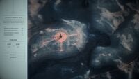
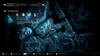
A '''tactical map''' ('''TACMAP''') are virtualized maps utilized by personnel of the [[ | [[File:HINF Intel5 Concord.jpg|thumb|300px|A planet wide TACMAP of [[Concord]], used by the [[UNSC Army]] during the [[Defense of Concord]].{{Ref/Reuse|S2StoryHub}}]] | ||
A '''tactical map''' ('''TACMAP''') are virtualized maps utilized by personnel of the [[United Nations Space Command]] armed forces.{{Ref/Novel|Id=fs2|Halo: First Strike|Chapter=2}} | |||
==Overview== | |||
TACMAPs display information on terrain and geography, provided by satellite imagery and topographic surveys. Accessible through [[data pad]]s or [[heads-up display]]s, these maps can be interfaced with navigation markers to identify targets, and relevant data can be shared through the [[UNSC battle network]].{{Ref/Reuse|fs2}} A unit's TACMAP is maintained by an intelligence [[squad]], responsible for gathering new data with reconnaissance [[drone]]s and establishing TACMAP linkups to HUDs.{{Ref/Novel|Id=fs9|Halo: Silent Storm|Chapter=8}} | |||
TACMAP can be used to identify allies and squadmates,{{Ref/Novel|Id=goopro|Halo: Ghosts of Onyx|Section=Prologue}} with teammates transmitting their locating to their unit through TACMAP.{{Ref/Novel|Halo: Last Light|Chapter=15}} Hostiles appear through TACMAP in the form of red ovals.{{Ref/Reuse|goopro}} Mission objectives are also stored with TACMAP.{{Ref/Novel|Halo: Silent Storm|Chapter=2}} TACMAPs are primarily used by [[Spartans]], integrated into the HUD interface of the [[MJOLNIR Powered Assault Armor]] or [[Semi-Powered Infiltration Armor]].{{Ref/Reuse|fs9}}{{Ref/Reuse|goopro}} A similar navigation feature can also be used by the [[Orbital Drop Shock Trooper]]s, as a component of the [[Visual Intelligence System, Reconnaissance|VISR system]] in their [[ODST Ballistic Battle Armor|armor]].{{Ref/Game|Id=odst|Halo 3: ODST}} | |||
The scale of the TACMAP can be anywhere from a district of a [[city]]{{Ref/Reuse|odst}} to a whole [[planet]].{{Ref/Site|Id=S2StoryHub|URL=https://www.halowaypoint.com/en-ca/halo-infinite|Site=Halo Waypoint|Page=Halo Infinite|Detail=Season 02 Lone Wolves - Story & Intel|D=04|M=10|Y=2022}} | |||
==Gameplay== | |||
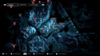
[[File:HINF Pre-Release TACMAP.png|thumb|250px|The TACMAP used on the [[MJOLNIR Powered Assault Armor (GEN3)|MJOLNIR [GEN3] armor]].]] | |||
===''Halo 3: ODST''=== | |||
In [[campaign]] and [[Firefight]], the TACMAP is available on the "NAV" tab in the [[Visual Intelligence System, Reconnaissance|VISR]] database. Players can use the TACMAP to locate objectives and beacons in each level. The TACMAP provides real-time location of enemies (shown as red dots) and other players (shown as green dots) on the map. In campaign, players can place a waypoint on the TACMAP, and its location would also appear on the HUD's compass during gameplay. | |||
===''Halo Infinite''=== | |||
{{Expand-section}} | |||
{{Clear}} | |||
==Gallery== | ==Gallery== | ||
===Concept art=== | |||
<gallery> | |||
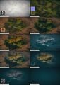
File:HINF Concept TACMAP1.jpg|Early concept exploration of the TACMAP in ''[[Halo Infinite]]''. | |||
File:HINF Concept TACMAP2.jpg|More early concept exploration. | |||
File:HINF Concept TACMAP3.jpg|More early concept exploration. | |||
File:HINF Concept TACMAP4.jpg|More early concept exploration. | |||
File:HINF Concept TACMAP16.jpg|Early concept exploration of an overlay for the TACMAP. | |||
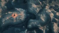
File:HINF Concept TACMAP6.jpg|Concept exploration of terrain. | |||
File:HINF Concept TACMAP10.jpg|More concept exploration of terrain. | |||
File:HINF Concept TACMAP8.jpg|Concept exploration of terrain featuring [[Forerunner]] structures. | |||
File:HINF Concept TACMAP11.jpg|More concept exploration of terrain. | |||
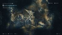
File:HINF Concept TACMAP13.jpg|The previous concept with UI overlay. Curiously, it describes the location as being [[Installation 06]]. | |||
File:HINF Concept TACMAP5.jpg|More concept exploration of terrain for the TACMAP. | |||
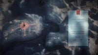
File:HINF Concept TACMAP14.jpg|The previous concept with UI overlay describing mission objectives. | |||
File:HINF Concept TACMAP15.jpg|The previous concept again with another variation of UI overlay. | |||
File:HINF Concept TACMAP7.jpg|Concept exploration of icons representing location held by the [[Banished]]. | |||
File:HINF Concept TACMAP12.jpg|More concept exploration of icons representing the Banished. | |||
File:HINF Concept TACMAP9.jpg|Concept exploration of explored and unexplored regions on the TACMAP. | |||
File:HINF Concept TACMAP17.jpg|Concept exploration of a region both with and without the [[Wikipedia:Fog of war#In video games|fog of war]]. | |||
</gallery> | |||
===Screenshots=== | |||
<gallery> | <gallery> | ||
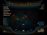
File:HINF XGS2020 TACMAP.png|TACMAP | File:VISR Database.jpg|The TACMAP provided to [[ODST]]s via their [[VISR|VISR system]] in ''Halo 3: ODST''. | ||
File:HINF_XGS2020_TACMAP_2.png|TACMAP | File:HINF XGS2020 TACMAP.png|An early build of the TACMAP in the [[Halo Infinite Campaign Gameplay Premiere|''Halo Infinite'' Campaign Gameplay Premiere]]. | ||
File:HINF XGS 2020 TACMAP full.png|UI-less version of the TACMAP | File:HINF_XGS2020_TACMAP_2.png|An early build of the TACMAP in the ''Halo Infinite'' Campaign Gameplay Premiere. | ||
File:HINF XGS 2020 TACMAP full.png|UI-less version of the TACMAP in the ''Halo Infinite'' Campaign Gameplay Premiere. | |||
</gallery> | </gallery> | ||
| Line 15: | Line 50: | ||
*''[[Halo: First Strike]]'' {{1st}} | *''[[Halo: First Strike]]'' {{1st}} | ||
*''[[Halo: Ghosts of Onyx]]'' | *''[[Halo: Ghosts of Onyx]]'' | ||
*''[[Halo 3: ODST]]'' | |||
*''[[Halo: Last Light]]'' | *''[[Halo: Last Light]]'' | ||
*''[[Halo: Retribution]]'' | *''[[Halo: Retribution]]'' | ||
| Line 21: | Line 57: | ||
==Sources== | ==Sources== | ||
{{Ref/Sources}} | |||
[[Category:UNSC technology]] | [[Category:UNSC technology]] | ||
[[Category:Navigation]] | [[Category:Navigation]] | ||
Latest revision as of 18:50, August 28, 2023

A tactical map (TACMAP) are virtualized maps utilized by personnel of the United Nations Space Command armed forces.[2]
Overview[edit]
TACMAPs display information on terrain and geography, provided by satellite imagery and topographic surveys. Accessible through data pads or heads-up displays, these maps can be interfaced with navigation markers to identify targets, and relevant data can be shared through the UNSC battle network.[2] A unit's TACMAP is maintained by an intelligence squad, responsible for gathering new data with reconnaissance drones and establishing TACMAP linkups to HUDs.[3]
TACMAP can be used to identify allies and squadmates,[4] with teammates transmitting their locating to their unit through TACMAP.[5] Hostiles appear through TACMAP in the form of red ovals.[4] Mission objectives are also stored with TACMAP.[6] TACMAPs are primarily used by Spartans, integrated into the HUD interface of the MJOLNIR Powered Assault Armor or Semi-Powered Infiltration Armor.[3][4] A similar navigation feature can also be used by the Orbital Drop Shock Troopers, as a component of the VISR system in their armor.[7]
The scale of the TACMAP can be anywhere from a district of a city[7] to a whole planet.[1]
Gameplay[edit]

Halo 3: ODST[edit]
In campaign and Firefight, the TACMAP is available on the "NAV" tab in the VISR database. Players can use the TACMAP to locate objectives and beacons in each level. The TACMAP provides real-time location of enemies (shown as red dots) and other players (shown as green dots) on the map. In campaign, players can place a waypoint on the TACMAP, and its location would also appear on the HUD's compass during gameplay.
Halo Infinite[edit]
 This section needs expansion. You can help Halopedia by expanding it.
Gallery[edit]
Concept art[edit]

Early concept exploration of the TACMAP in Halo Infinite.
More early concept exploration.

More early concept exploration.

More early concept exploration.

Early concept exploration of an overlay for the TACMAP.

Concept exploration of terrain.

More concept exploration of terrain.

Concept exploration of terrain featuring Forerunner structures.

More concept exploration of terrain.
The previous concept with UI overlay. Curiously, it describes the location as being Installation 06.
More concept exploration of terrain for the TACMAP.
The previous concept with UI overlay describing mission objectives.
The previous concept again with another variation of UI overlay.

Concept exploration of icons representing location held by the Banished.
More concept exploration of icons representing the Banished.

Concept exploration of explored and unexplored regions on the TACMAP.

Concept exploration of a region both with and without the fog of war.


Screenshots[edit]
The TACMAP provided to ODSTs via their VISR system in Halo 3: ODST.
An early build of the TACMAP in the Halo Infinite Campaign Gameplay Premiere.
An early build of the TACMAP in the Halo Infinite Campaign Gameplay Premiere.
UI-less version of the TACMAP in the Halo Infinite Campaign Gameplay Premiere.


List of appearances[edit]
- Halo: First Strike (First appearance)
- Halo: Ghosts of Onyx
- Halo 3: ODST
- Halo: Last Light
- Halo: Retribution
- Halo: Silent Storm
- Halo Infinite
Sources[edit]
- ^ a b Halo Waypoint, Halo Infinite: Season 02 Lone Wolves - Story & Intel (Retrieved on Oct 4, 2022) [archive]
- ^ a b Halo: First Strike, chapter 2
- ^ a b Halo: Silent Storm, chapter 8
- ^ a b c Halo: Ghosts of Onyx - Prologue
- ^ Halo: Last Light, chapter 15
- ^ Halo: Silent Storm, chapter 2
- ^ a b Halo 3: ODST


